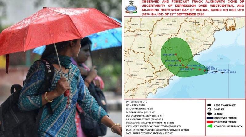
Where is Cyclone Arnab now?
According to the IMD’s coastal weather bulletin, the cyclone was centred over the west-central Bay of Bengal at 11:30 pm Indian time on 26 October, approximately 350 kilometres southeast of Visakhapatnam, 420 kilometres east-southeast of Kakinada, 400 kilometres south-southeast of Gopalpur and 590 kilometres east of Bapatla.
The storm was tracking west-northwest and was forecast to turn northwest towards the Andhra Pradesh coast.
The IMD’s bulletin confirmed that Arnab had strengthened into a very severe cyclonic storm. These are the latest observed coordinates available for this report, rather than a live position at the time of publication.
Andhra Pradesh: Evacuations Underway as Coastal Districts Face the Greatest Danger
Andhra Pradesh is expected to experience the most direct impact of Cyclone Arnab.
Chief Minister N. Chandrababu Naidu has reviewed emergency preparations and directed officials to relocate people from vulnerable and low-lying areas.
The districts covered by evacuation and precautionary measures include Srikakulam, Vizianagaram, Visakhapatnam, Konaseema, East Godavari, West Godavari, Eluru, Krishna, NTR, Guntur, Palnadu, Bapatla, Prakasam and Nellore.
According to Indian media reports, 4,711 pregnant women from vulnerable locations have already been moved to primary health centres, community health centres and hospitals.
Educational institutions in affected districts have been ordered closed from 27 to 31 October.
Seven National Disaster Response Force teams and eight State Disaster Response Force teams have been deployed, with additional resources available if required.
The greatest concern is not confined to coastal winds. The IMD has issued red rainfall alerts for districts including Kakinada, Eluru, East Godavari, West Godavari, NTR and Krishna, where isolated locations could receive more than 200 millimetres of rain within 24 hours.
Such rainfall could overwhelm drainage systems, flood roads, damage crops and isolate communities, particularly in low-lying areas.
Odisha: Schools Close as Southern Districts Prepare for Heavy Rain
Although the cyclone’s projected landfall is in Andhra Pradesh, neighbouring Odisha faces a significant threat from intense rainfall, strong winds and flooding.
The Odisha government has identified Ganjam, Gajapati, Rayagada, Malkangiri, Koraput and Nabarangpur as priority districts for emergency preparations.
Schools, colleges and Anganwadi centres in several vulnerable districts have been ordered closed as a precaution.
Authorities have also restricted fishing activities and tourist access to hills, waterfalls and dams in designated high-risk areas.
Chief Minister Mohan Charan Majhi has assigned eight ministers to oversee preparedness and coordinate emergency arrangements.
Odisha’s experience with previous cyclones has made early evacuation and shelter preparation central to its disaster response. Nevertheless, heavy rainfall remains a serious concern, particularly in communities vulnerable to flooding and landslides.
Which Other Indian States Could Be Affected?
While Andhra Pradesh and Odisha are the immediate focus, the cyclone’s effects may extend inland as the weather system weakens and moves across the country.
Andhra Pradesh and Yanam: Direct cyclone landfall, destructive winds, extreme rainfall and flooding are the primary concerns.
Odisha: Heavy to extremely heavy rainfall, strong winds and flooding are possible, particularly across southern districts.
Telangana: Heavy rain and thunderstorms may affect parts of the state as the system moves inland.
Chhattisgarh: Rainfall and thunderstorms are possible as the cyclone weakens after landfall.
Uttar Pradesh: Unseasonal rainfall, thunderstorms and gusty winds could affect several districts between 28 and 31 October.
Bihar: Parts of the state may experience rainfall associated with the system’s movement farther inland.
These are not equivalent warnings. Andhra Pradesh faces the forecast landfall, while more distant states are primarily monitoring potential rainfall and associated weather effects.
Why Cyclone Arnab Is Particularly Dangerous
Cyclone Arnab presents three major hazards: powerful winds, intense rainfall and dangerous coastal conditions.
Winds approaching 140 km/h in gusts can damage roofs, uproot trees, bring down power lines and disrupt telecommunications.
Heavy rainfall may be equally destructive. When large amounts of rain fall over a short period, rivers and drainage networks can exceed capacity, flooding homes, agricultural land and transport routes.
Coastal areas face the additional danger of rough seas, large waves and storm-driven seawater inundation. The severity of coastal flooding will depend on local geography, tides and the storm’s exact track.
The IMD has warned of extremely dangerous sea conditions near the storm’s centre, making marine activities particularly hazardous.
Fishermen have been advised to avoid affected waters, while boats already at sea have been instructed to return to safety.
Transport, Electricity and Essential Services: What Could Be Disrupted?
The cyclone could affect daily life well beyond the immediate landfall area.
Strong winds and flooding may force changes to road, rail and flight operations, while damaged electricity infrastructure could cause power cuts.
Mobile networks, internet services and water supplies may also be affected if infrastructure is damaged.
Agricultural communities face the possibility of crop losses, waterlogging and damage to stored produce.
However, the scale of disruption cannot yet be established. Any reports of cancelled flights, suspended trains, casualties or damaged infrastructure should be checked against official announcements rather than assumed from the cyclone forecast.
Why the Bay of Bengal Faces Repeated Cyclone Threats
The Bay of Bengal is one of the world’s most cyclone-prone regions.
Its warm waters provide energy for developing tropical storms, while the shape of its coastline and shallow coastal waters can amplify the consequences of storm surge.
Densely populated coastal settlements, river deltas and agricultural communities add to the potential human and economic impact.
India’s eastern states have experienced numerous damaging cyclones, including Hudhud in 2014, Fani in 2019 and Amphan in 2020.
These events have also contributed to improvements in forecasting, early-warning systems, evacuation planning and disaster-response coordination.
Cyclone Arnab will be another important test of those preparations.
What Cyclone Arnab Means for Indians Living Overseas
For Indian communities in New Zealand, Australia, the United Kingdom, the United States, Canada, the Gulf countries and elsewhere, the cyclone may be thousands of kilometres away, but the concern is much closer to home.
Families with relatives in Andhra Pradesh, Odisha and neighbouring states may face difficulties contacting loved ones if electricity or telecommunications services are interrupted.
People planning travel to affected regions should check directly with airlines, railway operators and local authorities before departure.
Those sending assistance or financial support should use verified government agencies and established relief organisations, particularly if fundraising appeals begin circulating on social media.
New Zealand Comparison: Lessons from Cyclone Gabrielle
New Zealand experienced the devastating consequences of extreme weather when Cyclone Gabrielle struck in February 2023.
The cyclone caused extensive flooding, landslides, infrastructure damage and displacement, particularly across Hawke’s Bay and Tairāwhiti.
Although Gabrielle and Arnab are different weather systems affecting very different geographical regions, the comparison highlights a common reality: a cyclone’s most serious consequences often extend beyond the period of strongest winds.
Flooded roads, damaged bridges, disrupted communications and prolonged power outages can make recovery difficult even after the weather improves.
India’s coastal population density and exposure to storm surge create additional challenges, while New Zealand’s steep terrain can intensify landslide and river-flooding risks.
The experiences of both countries underline the importance of early warnings, coordinated evacuations and resilient infrastructure.
Cyclone Arnab does not present a direct meteorological threat to New Zealand.
What Residents in Affected Areas Should Do
People living in areas covered by official cyclone warnings should prioritise instructions issued by local authorities.
Residents should follow IMD updates and district evacuation orders, move to designated shelters when instructed and keep drinking water, essential medicines, identification documents, torches and charged mobile phones accessible.
People should avoid beaches, rivers, flooded roads and unnecessary travel. Fallen electricity lines and damaged structures must be treated as dangerous.
Special attention should be given to elderly residents, children, pregnant women and people requiring medical assistance.
Families outside India should establish contact with relatives before conditions deteriorate and avoid circulating unverified videos, casualty figures or emergency messages.
What Happens Next?
The next major milestone is the forecast landfall on Wednesday morning, 28 October.
Meteorologists will continue monitoring the cyclone’s position, intensity, rainfall distribution and movement after it crosses the coast.
Once inland, the storm is expected to weaken, but heavy rainfall and flooding may continue to affect communities beyond the immediate landfall zone.
The eventual impact will depend on several factors, including the exact point of landfall, the duration of heavy rainfall, local flooding conditions and the effectiveness of evacuation measures.
At the time of this report, no final assessment of damage or casualties can be made because the cyclone has not yet reached land.
A Critical 24 Hours for India’s Eastern Coast
For hundreds of thousands of residents along India’s eastern coastline, the immediate priority is safety.
The preparations underway in Andhra Pradesh and Odisha reflect the seriousness of the threat, but the effectiveness of early evacuation, public warnings and emergency coordination will become clearer as the storm approaches.
For families across India and the global Indian diaspora, the coming hours will be a period of concern and close attention.
Cyclone Arnab is approaching a densely populated coastline. Its full impact remains uncertain, but the window for precautionary action is narrowing.
Webfit News will continue monitoring official updates from the India Meteorological Department and relevant state disaster management authorities.
Source: India Meteorological Department, Andhra Pradesh State Disaster Management Authority, government advisories and Indian media reporting.
Editorial update: 27 October 2026. Weather forecasts and emergency instructions are subject to change.